
The Marblehead UFO: What You Can Find from Your Armchair
21August 18, 2013 by kittynh
The following is a post by my friend Andrew Hansford. He presented a Sunday morning paper at TAM 2013 on this investigation. It’s a good primer for all of us about how we can learn a lot, just from our armchair (and a computer of course!)
The Report
On October 26, 2011, just before sunrise, photographer Eyal Oren, hoping to capture the unusual sky condition of that morning, took a series of shots of an old anchor on a beach in Marblehead, Massachusetts. (See Image 1) While processing the photographs, he noticed a small bright spot near the right edge that moved from one photo to the next. After posting the still on his photo blog, he cropped the sections of the series containing the light, and posted a short animation of the object and described the incident in his blog. An online publication specializing in local news reported the story about the mysterious object over Massachusetts Bay. Subsequently, several UFO and local websites including WCVB-TV picked up on the story. 
Image 1: Photograph from webpage with close-up of the UFO
The story did not get much traction after the initial report and did not become the center of a large flap. The report was treated as a Halloween mystery and the article in the Marblehead Reporter including the cliché “Recent sighting defy easy explanation” along with descriptions including “It was as bright as the sun, the brightest thing out there” and “It’s basically just sitting there for two minutes. A plane wouldn’t stay there for two minutes without moving.” The only thing lacking was an expert to be baffled.
I looked at the photograph and the cropped animation and thought that the object DID move like a plane in the distance. Even the animation showed the object moving slightly against the clouds before moving rapidly out of frame to the right. The motion can be explained if the object were approaching the photographer nearly head-on and then turning. The Massachusetts Bay is in the operation area of Boston Logan airport. I wanted to reply to the article and blog post but without any evidence, my speculation — although a likely explanation — would sound dismissive. With only the photograph, the newspaper story and the cropped animation how can we show that the object is likely a plane? Can we build a case from the evidence for a rational explanation or must we let the mystery mongers go unchallenged?
When and Where did this Happen?
From the article we know the series of photographs was taken between on 2011-10-26 between 06:58:36 AM and 07:00:35AM at Preston Beach in Marblehead, MA. Looking at the photograph itself we see a prominent landmark and an island which we can use to tell where the camera was pointing and the approximate location of the photographer. (See Image 2)

Image 2: Massachusetts Bay and Marblehead (from Google Maps)
Zooming on the beach we can see the anchor. (See Image 3) (The green arrow shows the location of the camera later provided by the photographer after I presented him with my initial findings. He also confirmed that his camera was only 12 seconds off UTC.)

Image 3: Preston Beach, Marblehead, MA (from Google Maps)
Were there any Planes in the Area?
Now we have a good idea of the time and place. How can we check if there are any planes in the area? Boston Logan radar information is available from Passur. This site not only shows live radar but also allow playback of the radar data for about 2 weeks. Using that tool I could see that the approach pattern that aircraft were using that morning took them out over Massachusetts Bay, with a left turn to a Base leg (a short descending flight path perpendicular to the runway) and another left turn to final approach on Runway 27. This flight path can also explain the apparent motion of the object. The base leg toward an observer on Preston Beach would cause very little apparent motion during a slow decent followed by a rapid motion to the observer’s right as the aircraft turned left for final.
The radar data showed that best candidate aircraft is JetBlue flight 1250 from Washing Dulles to Boston Logan arriving at 07:08 AM. Another site, Flightaware, provides historic flight information including ground track and flight profile information for our candidate flight. (See Image 4)

Image 4: Jetblue 1250 Track and Profile (from Flightaware.com)
Is that plane visible?
The case looks good so far. But would the aircraft been visible in the shot? Looking at the photograph again we can see that there are clouds overhead but not on the horizon. The bottoms of the clouds to the east are actually lit up but the clouds over the observer and over the object are still dark gray. These are unusual conditions but it was the reason the photographer was out that day.
Using the NOAA solar calculator we see that local sunrise at the green marker on that day was 07:09 AM. About 10 minutes after the photograph is taken. The bright horizon is glare and not direct sun. Still we see we have lots of light coming in from the east from BELOW the clouds. We can also plot the direction of the sunrise from the green marker. (Image 5)
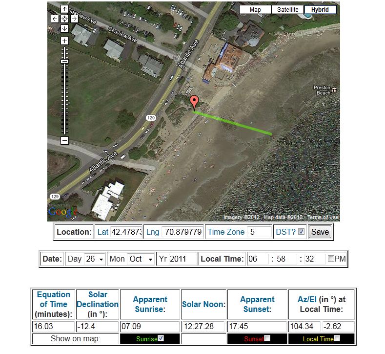
Image 5: Sunrise Calculation and Direction (from NOAA)
We can see that the direction of sunrise is right over the anchor and lines up well with the photograph. We can use this line as the approximate centerline for the direction the camera is pointed. (This could be refined by aligning the island and anchor image carefully.)
What about the clouds? The object is obviously below them giving us an idea of the maximum altitude of the object. Every airport generates weather reports every hour to aid pilots using the airport or passing through the area. These reports (called METAR) are available at Plymouth State among other places. This report from Boston Logan on the morning of Oct 26, 2011:
ID TIME T TD RH DIR SPD GST ALT SLP VIS CIL COV
KBOS 1054 49 34 56 290 7 994 139 10 70 OVC
Translated is says at 10:54UTC (06:54 EDT) light winds from the west with clouds at 7000ft.
Now we know bottom of the clouds in the photograph are at 7000ft and the object must be below that. Now looking at the at the flight profile of our candidate we see that the aircraft descended below 7000ft at about 06:55 reaching about 5000ft at 06:58. This would have put the aircraft well below the clouds and in the glare of the horizon. (N.B. I initially thought that the airplane would be in the the sun due to its altitude. The rule of thumb is that the sunrise will appear a minute earlier for each mile of altitude. Since the photos are 11 – 7 minutes before sunrise the airplane was NOT in direct sun.)
How do we tell how wide the shot is? We could work this out from the image but there is another way. The width of the shot (also known as Horizontal Field of View) can be determined from knowing the focal length (distance from the center of the lens or in this case the effective distance since this is a multi-lens system) and the width of the imager. (Figure 1)

Figure 1: FOV Calculation Diagram
Horizontal Field of View = 2x arctan (0.5 imager width / focal length)
So how am I supposed to know the focal length and the imager width? Digital photographs have extra information about the image called EXIF data. Items such as time and geo-location are common. Other common information includes the camera and lens equipment and the exposure time, ISO, aperture, and focal length of the shot. I fed the JPEG image from the website to an analysis tool and found that the image was made with a Canon E0S 50D Using an EF-S17-55 lens with a 2 second exposure and a 33mm focal length. Checking the Canon website shows the 50D uses a 22.3mm wide silicon imager. Solving the equation above we see the shot is 37.3 degrees wide.
Bringing it together
Overlaying the flight ground track onto the sunrise direction line (which we are using as the camera centerline) with a 37.3 degree overlay we see that the flight path does intersect with the field of view of the camera. (Image 6)
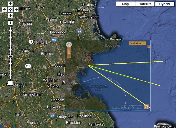
Image 6: FOV and Flight Path Overlay
Better Visualization
Everything looks good. But is there a way to combine all of this in a simulated 3D model? Google earth provides 3D visualization and allows photo graphic overlays and 3D shapes. FlightAware actually outputs a file compatible with Google earth that will plot the flight path of an aircraft in 3D with timestamps. You can see the button in Image 4. All we need then is a way to line up the photograph. The anchor is actually not in Google earth, but the island is. Since we know the camera position exactly, we just need to adjust the direction the camera is pointing and the field of view.
After fitting the photo in Google earth the horizontal field of view is show as 37 degree which agrees with our theoretical calculations. Adding the 3D flight path shows the white dot in the image extremely close to the plotted point at the time the photo was taken (06:58:24). Furthermore the path and timing of the Google earth Model matches very closely with the movement in the original animated sequence. We see the aircraft enter the frame at 06:58:16 moving toward the left, it reaches its left most point around 06:59:22 and then barely moves in the frame until 07:00:12 then moves toward the right of frame exiting at 07:01:06. (Images 7-10)
 Image 7: Google earth Overlay with Flight Path 06:58:32
 Image 8: Google earth Overlay with Flight Path 06:59:22
 Image 9: Google earth Overlay with Flight Path 07:00:12
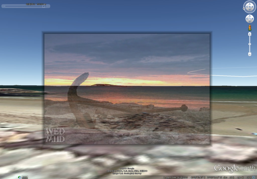 Image 10: Google earth Overlay with Flight Path 07:01:02
Airliners.net has a HUGE database of airplane photographs. There are many photographs of Jetblue ERJ-190.
Conclusion
The object in the photographs closely matches the flight path of Jetblue 1250. The aircraft should have been in the photos taken on that morning. If the object is not JetBlue 1250, then Jetblue is missing aircraft.
This is a relatively simple example of how an event can be reconstructed using what seems to be a small amount of information to start. The seeming lack of evidence makes a case rife for wild speculation. Using online resources, one can find evidence to support an explanation instead of just chiming in as one of the many speculators.
Related articles
- TAM 2013 Recap… (skepticalhumanities.com)
- Visiting Marblehead Skippers Welcome (marbleheadsailing.wordpress.com)
- Another UFO investigation Done, Evidence of Star Like UFO’s Uncovered and more! (tpa222.wordpress.com)
- Night Vision UFO – Spherical UFO Filmed While, Followed By Drone Over Oregon, USA (ufo-blogger.com)

I had no idea! cool article!
This is BRILLIANT! I am the photographer and came here after a ‘pingback’ on my site. So happy to see this carefully reconstructed story and am happy that the UFO has now been identified. Thank you Andrew. Really appreciate your time with this.
oh so lovely you like the article. Andrew did a great job and we all enjoyed hearing his talk at TAM 2013. Your photograph is “famous”!
[…] The Marblehead UFO: What You Can Find from Your Armchair | Yankee Skeptic August 18, 2013 at 5:23 pm – Reply […]
[…] Two years later and Andrew Hansford has put together an incredibly detailed and meticulously researched account of this morning. He has identified the UFO but you’ll have to read this blog post to figure out the answer: READ MORE […]
Wow! Very cool! If you like photography or research or airplanes……this is a great article!
[…] also suggest you read Andrew Hansford’s investigation of a UFO photo (just posted yesterday), which he also presented at TAM 2013. It’s a fine example of using […]
What a fantastic example of skepticism in action. I hope UFO enthusiasts take a lesson here in how a UFO investigation SHOULD be done. Well done, Andrew.
Great article and great debunking!
I just love how the conclusion is that the plane HAD to be there. You can’t get much more thorough than that. I hope to see the video of that TAM talk one day.
Good job. Reminds me of the deconstruction of the Los Angeles “mystery missile.”
http://contrailscience.com/los-angeles-missile-contrail-explained-in-pictures/
They used flight data from FlightWise.com
Mick over at contrailscience recommended the Google earth approach to me and gave me some pointers to start. It is a great visualization and investigation tool. I hope to show more Google earth soon.
[…] Day The Marblehead UFO: What You Can Find from Your Armchair Bob Lazar not impressed with Area 51 declassification Area 51 Documents Jose Caravaca’s […]
[…] 2013 Amazing Meeting about how he examined a UFO case from Marblehead, MA. You can see his report here. He was able to glean the best answer and make a solid conclusion from rather few bits of initial […]
[…] The Marblehead UFO: What You Can Find from Your Armchair (yankeeskeptic.com) […]
Excellent. I agree.
Hi there to every one, it’s really a fastidious for me to visit this site, it contains useful Information.
About exif as well, have a look at this exif based photo search engine : http://www.exif-search.com
[…] digitale speurwerk van Hansford is in detail na te lezen op de Yankee Skeptic website, de gedachtegang kan als volgt samengevat […]
[…] 2013 Amazing Meeting about how he examined a UFO case from Marblehead, MA. You can see his report here. He was able to glean the best answer and make a solid conclusion from rather few bits of initial […]
The presentation given at TAM2013
Superb article. This is an excellent example of the scientific method at work.